Upper Mustang Trek
From (per person)
Upper Mustang Trek Highlights
• Explore Lo Manthang, the ancient walled capital of the Mustang Kingdom.
• Visit Lo Gekar Monastery, one of the oldest Buddhist sites in the Himalayas.
• Discover the Chhoser Caves, a network of man-made sky caves above the Kali Gandaki.
• Trek through dramatic red-cliff landscapes, eroded canyons, and desert plateaus.
• Reach Muktinath (3,760 m), a sacred pilgrimage site for Hindus and Buddhists.
• Fly over the Annapurna and Dhaulagiri ranges on scenic mountain flights.
• Experience traditional Mustangi culture, architecture, and Tibetan Buddhist monasteries.
• Walk ancient trans-Himalayan trade routes once used by Tibetan salt traders.
• Explore the unique Luri Gompa cave temple near Yara village.
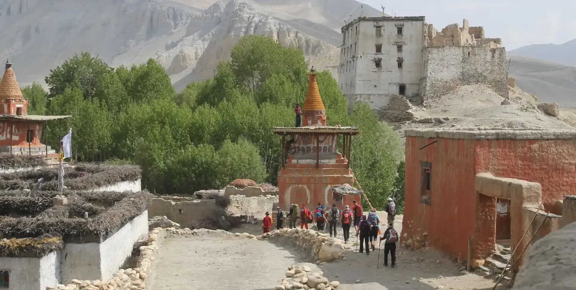
• Witness the walled city of Lo Manthang with its royal palace and four ancient gompas.
Upper Mustang Trek Overview
The Upper Mustang Trek takes trekkers into one of Nepal's most remote and culturally rich regions. Located in the northern rain shadow of the Annapurna and Dhaulagiri ranges, Mustang sits on the border with Tibet. The area receives very little rainfall, giving it a dry, desert-like landscape of red cliffs, deep gorges, and windswept plateaus.
The trek spans 18 days and begins with a flight to Pokhara, then a short mountain flight to Jomsom. From Jomsom, the trail heads north into the restricted zone through Kagbeni. Trekkers pass through traditional villages, cross mountain passes, and follow ancient trade paths. The terrain changes dramatically from green river valleys to stark, eroded badlands.
Lo Manthang stands as the centerpiece of the Upper Mustang Trek. This walled city served as the capital of the Lo Kingdom for centuries. Its narrow alleys, royal palace, and four functioning Buddhist monasteries remain largely intact. A day trip to the Chhoser Caves and a full exploration day allow trekkers to absorb the culture and history of this ancient settlement.
The return route follows a different path through Yara and Luri Gompa before descending to Muktinath. Muktinath is one of the most sacred pilgrimage destinations in Nepal, revered by both Hindus and Buddhists. The trek ends with a drive back to Jomsom and a flight to Pokhara, then onward to Kathmandu. Because Upper Mustang is a restricted area, trekkers must obtain a special permit before entering.
Upper Mustang Trek Itinerary
Tap any day to read the full programme.
Arrive at Tribhuvan International Airport in Kathmandu. A representative meets the group and transfers them to the hotel. The rest of the day allows time to rest and adjust to the altitude. In the evening, the team conducts a pre-trek briefing covering the program, permits, and packing requirements.
The morning starts with the preparation of the restricted area permit for Upper Mustang. Trekkers submit passport copies and photographs for permit processing. While permits are being arranged, the group takes a guided tour of Kathmandu's heritage sites. The tour covers Pashupatinath Temple, Boudhanath Stupa, Swayambhunath, and Kathmandu Durbar Square.
Pashupatinath is one of the most sacred Hindu temples in Asia, dedicated to Lord Shiva. Boudhanath is among the largest stupas in the world, built in the Tibetan Buddhist style. Swayambhunath, also known as the Monkey Temple, sits atop a hill and offers panoramic views of the Kathmandu Valley. In the afternoon, the group flies to Pokhara, a scenic lakeside city at 827 m. The flight takes approximately 25 minutes.
An early morning flight departs Pokhara for Jomsom. The 25-minute flight crosses some of the most dramatic mountain scenery in Nepal, with close views of the Annapurna and Dhaulagiri ranges. Jomsom serves as the administrative hub of the Mustang district and the starting point for the Upper Mustang Trek. After landing and completing formalities, the trek begins along the Kali Gandaki River.
The trail follows the riverbank north toward Kagbeni. The Kali Gandaki is one of the deepest gorges in the world, and its banks are scattered with ammonite fossils known locally as shaligrams. The walk to Kagbeni takes approximately three to four hours. Kagbeni is a compact, well-preserved village at the gateway to the Upper Mustang restricted zone. Its whitewashed buildings, narrow lanes, and red-ochre monastery give it a distinctly Tibetan character.
The trek officially enters the restricted area of Upper Mustang from Kagbeni. The trail heads due north along the Kali Gandaki River. Shortly after leaving Kagbeni, trekkers pass through Tangbe, a traditional village of whitewashed houses surrounded by small walled fields of buckwheat, barley, and apple trees. The path winds through a landscape of eroded cliffs and river terraces.
Further along, the trail reaches the confluence of the Narshing Khola and the Kali Gandaki. The village of Chuksang sits at this junction. The architecture here begins to show a clear Tibetan influence, with flat-roofed stone houses, prayer flags, and chortens marking the trail. The shift from the Manangi cultural zone to the Mustangi-Tibetan style becomes evident in the buildings and the dress of local residents. The total trek time for the day is approximately five hours.
The trail climbs steadily from Chuksang into higher terrain. The landscape transitions from the river valley into a more open, windswept environment of dry ridges and eroded gullies. The path crosses several small passes and descends into hidden valleys before climbing again. This section of the Upper Mustang Trek exposes trekkers to the raw, arid character of the Mustang plateau.
Samar is a small village set in a protected valley with apple and apricot trees. The village sits high above the main river valley and still offers clear views south of the Annapurna and Nilgiri peaks. Samar is known as a supply point for the sturdy pack ponies used by local traders. The elevation gain is significant, so the pace is kept steady throughout the four-to-five-hour walk.
Today's route climbs from Samar through a rugged desert landscape. The trail crosses the Yamdo La pass and moves through a series of eroded valleys and ridge traverses. The Mustang terrain here is dominated by multi-colored rock formations in shades of red, orange, and ochre. Prayer flags and chortens mark the high points of the trail.
Geling is a mid-sized settlement with a monastery and a cluster of traditional Mustangi homes. The village sits at the same elevation as Samar but occupies a broader valley with cultivated fields and stone walls. From Geling, views of the surrounding plateau and distant snowfields are clear on most days. The walk takes approximately five hours with moderate climbs and descents along the way.
The trail from Geling climbs toward the Nyi La pass, one of the highest points on the Upper Mustang Trek at approximately 4,010 m. From the top of Nyi La, trekkers enjoy 360-degree panoramic views stretching north to the Tibetan plateau and south to the Annapurna range. The descent from the pass leads through alpine meadows into a dramatic landscape of fluted red and purple cliffs.
Drakmar — meaning 'Red Cliffs' — sits beneath a striking wall of red rock formations. The cliffs are riddled with ancient caves once used by monks and local communities. The village itself is small, with a few stone houses and a local teahouse. The colors of the cliffs intensify in the late afternoon light, making Drakmar one of the most visually striking stops on the entire trek. The walk from Geling takes five to six hours.
This is one of the longest and most rewarding days of the Upper Mustang Trek. The trail crosses the Mui La pass and continues through a wide, open plain before reaching Lo Gekar. Lo Gekar Gompa is believed to be one of the oldest Buddhist monasteries in the entire Himalayan region, established by Guru Rinpoche during the 8th century. The gompa is decorated with ancient murals, statues, and large prayer wheels, and its grounds attract monks and pilgrims from across the region.
After visiting Lo Gekar, the trail continues across the plateau toward Lo Manthang. A short descent and then a steady climb leads to the walled city. Lo Manthang stands at 3,780 m and serves as the historic capital of the Mustang Kingdom. The city walls, palace, and monasteries remain standing after centuries of use. Arrival at Lo Manthang marks the northernmost point of the trek. The full walking time for the day is approximately seven hours.
A day trip from Lo Manthang leads north to the Chhoser Caves, also known as Luri Dhongphuk. These sky caves are carved into the cliff face high above the valley floor. Some chambers contain ancient murals and Buddhist artifacts, indicating religious use dating back over a thousand years. Researchers have also found human remains and manuscripts inside the cave complex.
The walk to Chhoser from Lo Manthang takes roughly two to three hours each way. The trail crosses open terrain and winds along the base of dramatic eroded cliffs. Access to the upper chambers requires climbing a wooden ladder or rope. The descent back to Lo Manthang follows the same route and takes a similar amount of time. The day offers a rare look into one of Mustang's least-known archaeological sites.
A full day remains in Lo Manthang for deeper exploration of the walled city. The city contains approximately 150 houses clustered tightly within its mud-brick walls. Most homes open onto a central courtyard, with living quarters on the upper floor and storage on the ground level. The royal palace, a four-story structure in the center of the city, is still ceremonially active and the king is respected in local affairs.
Four monasteries sit within the walls of Lo Manthang. Thubchen Gompa is the largest and contains a main assembly hall with tall Buddha statues and faded but remarkable murals. Jampa Lhakang houses a three-storey statue of Maitreya Buddha and features some of the finest mandala paintings in Nepal. Choede Gompa is the only active monastery in Upper Mustang where monks currently reside and conduct daily prayers. The fourth, Choprang, holds its own collection of religious artifacts and paintings. Each monastery offers a distinct experience and deserves a careful visit.
The return journey begins with a different route from Lo Manthang. The trail heads south and then turn onto a less-traveled path toward Yara. The route crosses the Marang La pass and descends through a wide valley. The landscape in this section varies from open grassland to rocky ridgelines and narrow gorges. Trekkers leave the plateau environment behind and move into slightly more vegetated terrain.
Yara is a small, quiet village set in a side valley of the Mustang region. The village has limited facilities but offers basic accommodation and meals. The surrounding area is known for its traditional lifestyle and relative isolation from the main trekking routes. The walk from Lo Manthang to Yara covers challenging terrain over approximately seven hours, with several ascents and descents along the way.
An acclimatization and exploration day focuses on the Luri Gompa, located above Yara village. The gompa is built into a natural cave in a cliff face and dates back to the 13th or 14th century. Inside, the cave walls are covered with well-preserved Buddhist murals painted in rich reds, blues, and golds. A large chorten stands within the cave, and the site serves as an active place of worship.
The walk up to Luri Gompa from Yara takes approximately two to three hours. The path climbs steeply through open terrain before reaching the cliff base. The cave entrance sits at 3,900 m, and the views from the cliff terrace are extensive. After exploring the gompa, the group descends back to Yara for the night. This is a rewarding half-day side trip with a few trekkers on the standard Mustang route experience.
The trail from Yara descends into the Mustang valley system and heads toward Tangye. The route passes through open terrain with views of the surrounding ridges and eroded cliff formations. Several small stream crossings and a few short ascents break up what is largely a descending day. The path connects through remote grazing areas and occasional stone shelters used by herders.
Tangye is a mid-elevation village that sits below the main Upper Mustang plateau. The village has a small community and basic amenities for trekkers. Arriving here marks a clear transition back toward the lower valley system. The descent in elevation from the previous day’s brings slightly warmer temperatures and a change in vegetation. The walk from Yara takes six to seven hours.
The trail continues its descent from Tangye back toward the Kali Gandaki valley. The route rejoins familiar terrain as it approaches Chuksang. The day involves walking through open, windswept landscape with the Kali Gandaki river system coming back into view. The trail follows ridges and drops into side valleys before arriving at the confluence near Chuksang.
Chuksang was visited earlier in the Upper Mustang Trek on Day 04. Returning here from a different direction highlights how the route forms a large loop through the restricted zone. The lower elevation brings noticeably warmer and calmer conditions compared to the exposed plateau. Trekkers rest here before the final days of the program leading back to Jomsom.
The final trekking day begins with a long climb from Chuksang toward Muktinath. The trail ascends through a series of villages and open hillsides. Jharkot, a fortified hilltop village, is passed on the way up. Just below Muktinath lies Ranipauwa, the service village that acts as the base for the temple complex. The full climb from Chuksang takes six to seven hours.
Muktinath Temple Complex sits at 3,760 m and holds great religious significance. The site includes a Vishnu temple, 108 waterspouts, a natural flame fed by underground gas, and a Buddhist gompa adjacent to the Hindu shrines. Both Hindu and Buddhist pilgrims travel here from across Nepal and India. After visiting Muktinath, the group drives back down to Jomsom through Kagbeni and along the Kali Gandaki. The drive takes approximately one to two hours.
An early morning flight departs Jomsom for Pokhara. The 25-minute flight retraces the mountain air route over the Annapurna foothills. Jomsom flights depart early due to strong afternoon winds in the Mustang valley. The group arrives in Pokhara by mid-morning. Pokhara sits at 827 m above sea level along the shores of Phewa Lake.
The rest of the day is free for personal exploration or rest. Pokhara offers lakeside walks, local cafes, and views of the Machhapuchhre (Fishtail) mountain from the waterfront. Boating on Phewa Lake, visiting the Devi's Fall, or simply relaxing are all common options. A celebratory dinner is held in the evening to mark the successful completion of the Upper Mustang Trek.
A morning flight from Pokhara returns the group to Kathmandu. The flight takes approximately 25 minutes and lands at Tribhuvan International Airport. Transfer to the hotel follows upon arrival. The afternoon is free for shopping, rest, or visiting any remaining sites in Kathmandu. Thamel, the main tourist district, offers a wide selection of trekking gear shops, bookstores, restaurants, and souvenir markets.
Trekkers who wish to extend their stay in Kathmandu can use the day for additional sightseeing. Popular options include Patan Durbar Square, the Kopan Monastery, or the Garden of Dreams. The evening marks the final night of the Upper Mustang Trek program in Nepal.
The program concludes on Day 18. Transfer to Tribhuvan International Airport is arranged according to the flight schedule. The team provides departure assistance and ensures all logistics are handled before the group leaves. Trekkers depart Nepal with a comprehensive experience of one of the Himalayan region's most restricted and historically significant trekking destinations.
Upper Mustang Trek Route Map
Route Map
Altitude Profile
Inclusions
• Private airport transfers in Kathmandu and Pokhara (arrival & departure)
• 2 nights at a 3-star Kathmandu hotel (twin-share, bed & breakfast)
• 2 nights at a 3-star Pokhara hotel (twin-share, bed & breakfast)
• Round-trip Kathmandu–Pokhara flights with standard baggage allowance
• Round-trip Pokhara–Jomsom flights with standard baggage allowance
• Shared local transfer from Muktinath to Jomsom
• 13 nights twin-share lodge accommodation during the trek
• Full-board meals throughout the trek (breakfast, lunch, dinner, tea & coffee)
• Drinking water and hot water for bottle refills at all lodge stops
• All required trekking permits (Annapurna Conservation Area, Mustang Restricted Area Permit & TIMS Card)
• Senior English-speaking, government-licensed lead guide, fully covered (wages, meals, accommodation & insurance)
• Assistant guide for every 4 clients, fully covered
• One porter per 2 clients (max 15 kg/client), fully covered
• Emergency medical kit throughout the trek
• Supplemental oxygen, mask & regulator for emergency use
Exclusions
• International Airfare to/from Kathmandu
• Nepal entry visa fee
• Personal travel, medical & emergency evacuation insurance (mandatory; arrange prior to departure)
• Lunch & dinner in Kathmandu and Pokhara
• Optional sightseeing in Kathmandu and Pokhara
• Additional hotel nights beyond the itinerary (available on request)
• Single room supplement or forced single room charges, where applicable
• Personal trekking gear & clothing (sleeping bag, boots, trekking poles, down jacket, etc.)
• Alcoholic beverages, specialty hot drinks & bottled/canned drinks during the trek
• Lodge extras charged locally: hot showers, battery charging & Wi-Fi
• Any personal expenses not listed under inclusion
• Guide & porter gratuities (recommended: USD 150/guide, USD 100/porter — at client's discretion)
Date & Price
Want a Private or Tailored Trip?
Book on your own dates, bring a private group, or adjust the itinerary. Our team replies within 24 hours.
Reviews
Write a review
No reviews yet. Be the first to share your experience.
Gallery
No gallery images available.
From (per person)
People also viewed